Spotting real public pickleball courts using Google Maps satellite view

Claude

A Google Maps pin for "pickleball" often leads straight to a cracked tennis surface with faded chalk lines and a sagging center net. To save local player krewes from ruined game mornings, the free mobile platform KrazyPickles recommends using satellite view as a virtual scout to verify court conditions before organizing a match. By analyzing exact layout footprints, shadow profiles from permanent nets, and color contrast on Google Earth, players in Northern Virginia and the broader Washington DC region can easily identify dedicated outdoor facilities versus poor shared-use compromises.
Analyzing the footprint ratio of tennis court conversions
Municipal parks departments are notorious for taking the path of least resistance when public demand for courts spikes. Instead of excavating new ground, local governments frequently repurpose existing, underutilized asphalt slabs. A 2025 analysis of high-resolution aerial photography found that over 26,000 outdoor pickleball courts were built recently across the United States, with more than 8,000 of those spaces created by taking over existing tennis surfaces FlowingData.
When you look at these parks from a satellite view, you need to understand the visual footprint of a true court. A standard tennis court requires a massive footprint of 60 by 120 feet including the overrun areas. By contrast, a single pickleball court footprint is much smaller, measuring exactly 20 by 44 feet Pickleball Sporting Goods. When you zoom in on a park using Google Maps, you can easily measure these areas to determine if you are looking at a dedicated layout or a lazy paint job.
The four-in-one tennis takeover
The most common municipal conversion layout is the four-in-one configuration, where four pickleball courts are squeezed into the boundaries of a single tennis court. On Google Maps, this looks like a cluster of four tiny rectangles packed tightly inside one large fence boundary. While this setup maximizes space, it often results in a poor playing experience.
From your satellite screen, look closely at the spacing between the outer lines of the small courts and the surrounding fences. If the margins look razor-thin, players will constantly run into the fence while chasing deep lobs. You will also notice a lack of physical barriers between the adjacent courts, meaning stray balls from the game next to you will interrupt your rallies every three minutes.
Measuring the 20x44 boundary
To verify if a court is built to proper specifications, use the built-in measurement tool on the desktop version of Google Maps. Right-click on the court surface and select "Measure distance" from the menu. Click on the corners of the painted lines to trace the boundary.
A true court will measure exactly 20 feet wide and 44 feet long, divided in half by a center line Pickleball Sporting Goods. Inside each half, you should see the 7-foot non-volley zone, commonly known as the kitchen. If your measurements do not match these specifications, or if the lines look warped and uneven from above, the local parks department likely let an untrained crew handle the painting.
Using shadow casting to identify permanent nets
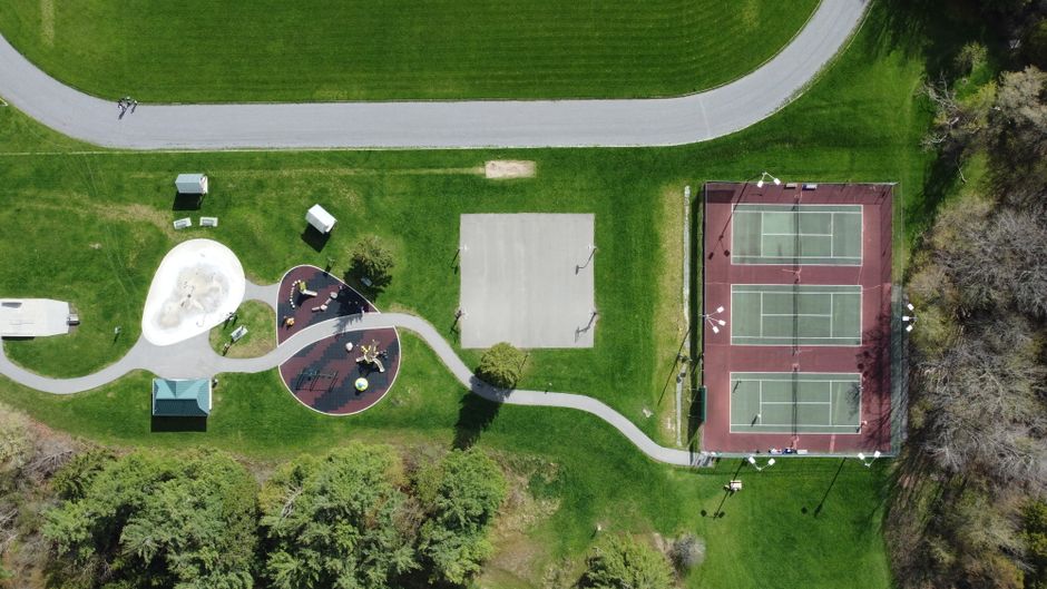
Many public parks are listed as having courts when they actually only have painted lines on the asphalt. If you show up to these locations without bringing your own portable net system, you will end up staring at an empty court. You can easily avoid this scenario by reading the shadows cast on the ground in raw satellite imagery.
Look for images taken during mid-morning or late afternoon when the sun is at an angle. During these times, vertical structures cast long, dark shadows across the playing surface. By examining these shadows, you can confirm whether a court has heavy-duty, permanent nets or if it is an empty flat surface.
A permanent net post is a thick steel column anchored directly into the concrete, standing just outside the 20-foot sidelines Pickleball Sporting Goods. On Google Maps, these posts cast distinct, dark, circular shadow points, with a thin, straight shadow line stretching between them across the center of the court. If you only see a flat painted line with no vertical shadow break at the edges, you are looking at a bring-your-own-net location.
Portable nets also leave telltale signs from above. Players often leave them set up at public parks, but these temporary systems have light frame structures and wide, flat steel bases. On satellite view, they look like thin, disorganized lines that are often slightly crooked or pushed to the side of the court to allow tennis players to use the space. If the net lines in the satellite image do not align perfectly with the court center lines, assume the site lacks permanent fixtures.

Surface color contrast and the shared-use paint trap
The paint scheme of a court tells you everything you need to know about how much a local municipality actually cares about the sport. Many parks departments opt for "shared-use" layouts, where they overlay pickleball lines directly on top of active tennis courts without changing the underlying surface color. This results in a confusing web of white, yellow, and blue lines that makes calling out-of-bounds shots almost impossible.
In the Washington DC and Northern Virginia area, venues like South Run District in Springfield feature these multi-sport setups Free Pickleball Courts Near Me | DC Area Guide | KrazyPickles. When you analyze these locations on Google Maps, the surface looks like a chaotic grid of intersecting lines. If your group is planning a competitive match or trying to run a local league session, these shared-use surfaces are highly frustrating.
Dedicated courts, on the other hand, feature high-contrast color zoning. Look for venues where the 7-foot non-volley kitchen is painted a completely different color than the surrounding service courts. For example, a court might feature a dark blue kitchen paired with light green service boxes. This stark visual contrast is highly visible even from low-resolution satellite sweeps.
High-contrast painted zones also indicate that the surface has been treated with a proper acrylic coating textured with silica sand. This texture provides traction and prevents players from slipping during quick lateral cuts. If the satellite view reveals a uniform, faded grey or dark black asphalt surface with thin lines painted directly on the raw pavement, expect a slippery, low-bounce surface that will tear up your shoes and ruin your games.
Checking mapping errors and municipal labels
You cannot always trust the green park icons or text labels that appear on the default Google Maps layer. The software often relies on user-submitted edits and outdated municipal databases that conflate community centers, indoor gyms, and multi-use blacktops. A location labeled "Pickleball Center" might actually be a middle school parking lot where a local club occasionally sets up temporary nets on Sunday mornings.
To get the real story, always toggle off the standard map view and switch to the raw satellite imagery layer. Zoom in close enough to inspect the actual ground conditions. If the map pin sits on top of a grassy field, a swimming pool, or a building roof, you know the geographical data is inaccurate.
Sometimes, a public park will have a mix of dedicated and shared-use spaces. For example, a facility might have six tennis courts, but only two of them have been lined for alternative play. By using satellite view to count the exact number of net shadows and painted rectangular boxes, you can determine the actual capacity of the facility. This helps you estimate wait times before you pack up your gear and drive to the venue.
If you want to save yourself the trouble of analyzing satellite images for every weekend session, you can compare local court qualities using structured community resources. For players in Northern Virginia, reviewing detailed regional analyses like the Arlington vs Fairfax NoVA public court scorecard can help you identify which county parks offer high-quality, dedicated playing surfaces and which ones only offer cracked, shared-use tennis conversions.
Finding verified courts without the manual satellite hunt
While using Google Earth to scout courts is a great skill, doing this level of manual research for every new venue is tedious. It is easy to miss subtle details like surface cracks, locked gates, or local priority-use rules that a satellite camera simply cannot capture from orbit.
| Feature | Dedicated Court | Shared-Use Conversion |
|---|---|---|
| Dimensions | Exact 20x44 feet with dedicated run-offs | Squeezed into tennis boundaries with limited space |
| Net Style | Permanent steel posts anchored in concrete | Portable systems or none provided |
| Line Clarity | Single, high-contrast set of boundary lines | Multiple overlapping lines for tennis and pickleball |
| Surface Coating | Textured acrylic paint for optimal traction | Raw asphalt or worn tennis court paint |
Instead of spending your evenings squinting at satellite pixels, you can leverage a platform that has already done the heavy lifting. The free KrazyPickles Court Finder provides a comprehensive directory of venues across the United States, with a heavy focus on the Washington DC and Northern Virginia regions. The directory filters courts by the metrics that actually matter to players, including indoor versus outdoor status, total court counts, lighting availability, and direct links to official reservation systems.
Once you find a high-quality court that fits your group, you can stop relying on messy, chaotic group chats to coordinate your matches. Using the platform, you can form private social groups called krewes, manage player RSVPs, and let the automated Picklebot handle post-game recaps and standings without ever touching a spreadsheet. If you want to learn more about selecting the perfect venue for your next match, check out our guide on how to find local pickleball courts that actually fit your group, or sign in to KrazyPickles today to claim your local court and start scheduling your games.


